We Took 24 Adventure Guides Kayaking at Pictured Rocks
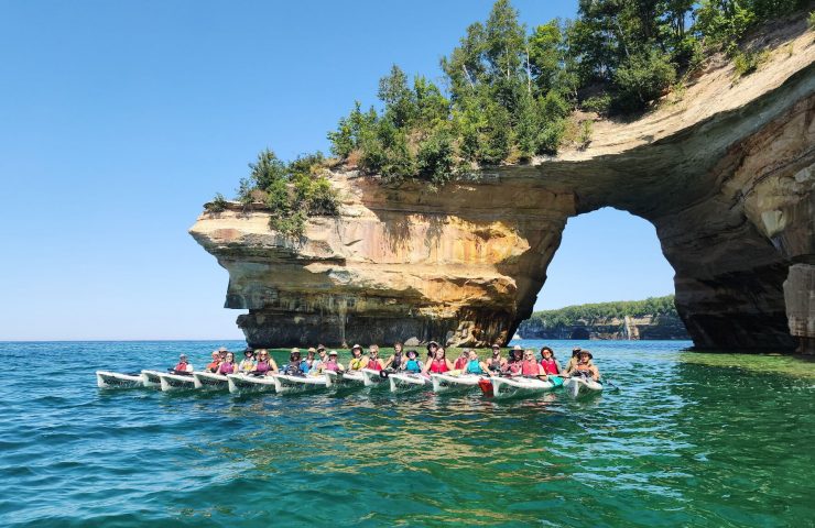
We Took 24 Adventure Guides Kayaking at Pictured Rocks. Here’s Why We Can’t Wait to Go Back.
On August 10, 24 members of the Wildman crew loaded into two vans and headed north to Munising for a five-hour, nine-mile kayaking trip along Pictured Rocks National Lakeshore.
Most of us spend the summer guiding whitewater rafting trips, so we needed to step it up from the typical company picnic. We’re used to giving safety talks, making bad guide jokes, and convincing other people that yes, they really can do the thing they signed up for.
For once, we got to be the guests.
We booked Big Water Paddle Company’s five-hour “Best of the Rocks” tour, which begins at Miner’s Beach, takes you along the cliffs to Lover’s Leap and back. It was Big Water’s first season in operation, though its three-person team had years of experience guiding the Pictured Rocks shoreline before launching their own company.
Their new shop sits off H-58 in the old Curly’s Hilltop building, a fact the locals apparently refuse to forget. Nearly as prominent as the new Big Water Paddle sign was another one beside it: “Yes, You Can Still Call It Curly’s Hilltop.”
Fair enough.
Because we rolled up with two vans full of raft guides, most of us brought our own PFDs. Big Water typically provides them, along with the rest of the required paddling equipment like a whistle, spray skirt, and drybag. We did borrow their spray skirts, which fit around your waist and seal over the kayak cockpit to keep water out. Imagine a pair of overalls, but if the bottom part ended up attaching you to a kayak instead of being two pant legs. Pretty sweet!
One of our guides, B$ — pronounced B-Money — gave us the pre-trip safety talk outside the shop. We’re used to being on the delivery side of guide humor, so it was fun to hear someone else work corny jokes into a safety briefing for once.
Then we paired up, loaded into the vans, and shuttled about 10 minutes down to our launch point at Miner’s Beach.
Twelve Tandem Kayaks and One Very Predictable Race
When we arrived, we had a beautiful view of the tandem sea kayaks that were already waiting for us on the sand contrasted against the turquoise waters of Lake Superior.
Our three guides, Miles, B$, and Loganne, helped everyone adjust their foot pedals and rudders before launch. The paddler in the back of the kayak presses those pedals with their feet to turn a rudder on the back of the craft. Quite useful for a 17-foot long boat that doesn’t exactly pivot on a dime.

B$ also gave us the primary rule of tandem kayaking:
The person in the back is doing an awesome job steering.
Whether or not this is actually true is irrelevant.
I paired up with my girl Emily. We both guide occasionally, but we’re more often found working in the office, behind the bar, or photographing Menominee rafting trips.
Once everyone had gotten comfortable maneuvering, Miles lined us up for a race to a boat about 200 yards down the beach.
I assume this isn’t standard programming, but if you put 24 adventure guides in kayaks, it’s bound to get competitive.
Although Emily and I were beautifully synchronized, it did not translate into speed. We didn’t win, but I’m pretty sure (I hope) we didn’t come in dead last.
What I do know is that my shoulders were already burning, which was slightly concerning considering we had several hours of paddling ahead of us.
The Water Was Almost Too Perfect
Once the pace settled down, we were really able to appreciate Lake Superior.
The day was hot, sunny, and almost windless. The glassy lake reflected bright turquoise, pairing perfectly with the layers of orange, pink, brown, and white sandstone along the cliff face.
Much of the exposed rock in this striking shoreline belongs to the Munising Formation, sandstone laid down roughly 500 million years ago. Over time, wind, water, freezing, and erosion carved the cliffs into arches, caves, overhangs, and narrow channels. Pictured Rocks gets its name from the colorful staining visible along its cliff faces. Mineral-rich groundwater paints the rocks fantastic colors: iron produces reds and oranges, copper contributes blue-green tones, and manganese darkens parts of the cliff face.

Don’t take it for granite.
Sorry!! Five hours with guides does that to a person.
The water was clear and still enough for us to really appreciate the submerged shelves of broken sandstone beneath us — pieces of the shoreline that had fallen away and settled on the lake bottom. Pro tip: if you want to stay in your kayak, lean the opposite direction of your partner when checking out anything below you.
While the cliffs are beautiful from above, it was so special to see them up close from the water!
The Best Days Let You Get Close
The conditions on Lake Superior don’t always cooperate.
Weather can change quickly, and the National Park Service is very clear that this is not casual flatwater paddling. On rougher days, wind and waves can completely change what parts of the shoreline are accessible.
We happened to get an unusually calm day, so the guides could bring us close to the cliffs and into several small caves and overhangs.
Some were wide enough to maneuver inside. Others required a straighter approach: point the kayak in, duck, back out.
As raft guides, we’re used to wearing helmets. Which we did not have. So… watch your head!
Groundwater also seeps through the sandstone and drips from the cliffs, which introduces another tandem-kayak question: how much do you like the person sitting in front of you? (You hold the power to position them underneath a gentle sprinkle or push them into a full-on shower.)
Emily and I worked up a sweat during our race, so we were perfectly happy to steer in tandem under the wetter sections.
The guides told us that if someone capsized, they could typically get that paddler back into the kayak in a couple of minutes. On Lake Superior, even in August, a couple of minutes can feel like a long time. If you’ve felt how chilly that water is, you’ll know what I mean!
We stayed upright.
The George Shipwreck
Farther along the shoreline, the guides called us away from the cliffs and told us to look down.
Sitting about 15 feet below us was the wreck of the George, a 200-foot schooner that ran aground during a storm in 1893.
The ship had been carrying coal toward Marquette when severe weather drove it onto the shore, and about 120 feet of the wooden hull remains visible in the shallow water today.
The lake was calm enough that we could paddle directly over the wreck and clearly see the timbers below us!
I came back later in the summer with my family on a windier day, and the difference was dramatic. It was hard enough to stay in one place without getting blown away from the wreck, and with more chop on the surface, the wreck was tougher to see even if you are right on top of it.
Lover’s Leap and the Nine-Mile Reality Check
We continued past Mosquito Beach toward Lover’s Leap, the famous sandstone arch marking our turnaround point on Big Water Paddle Co’s five-hour tour.
By the time we reached it, my shoulders were cooked… Nine miles sounds manageable when you read it on a tour page. It feels more substantial when you are several hours into paddling it.

We took the obligatory group photo beneath the arch, then turned back toward Mosquito Beach for lunch.
We stretched, checked out the nearby waterfall, skipped stones (difficult to do even on a calm-water day), and ate what may have been the best ham-and-Swiss sandwiches of our lives.
There was no outhouse at Mosquito Beach during our visit, which is also useful to know if you’re planning a five-hour paddle. Our group of outdoor enthusiasts had no problem using the facili-trees.
Switching Seats
After lunch, Emily and I switched places.
I’d been steering from the rear on the way out, which suited me well. I’ve been called bossy before. I prefer “detail-oriented.” However, I did appreciate the unobstructed view from the front! Without another paddler directly in front of me, I had an incredible view of the sparkling turquoise lake and towering golden cliffs while Emily took over the rudder.
She did an awesome job steering.
Obviously.
We kept a steady pace on the return trip, and by the time we reached the beach I was genuinely tired and considered spending It was re-assuring that our full-time river guides, who spend their summer paddling whitewater, were almost as wiped as I was.
How Hard Is the Five-Hour Pictured Rocks Kayak Tour?
Harder than I expected, but very doable for an active beginner.
The Best of the Rocks trip is nine miles. Even in calm conditions that means several hours of repeated paddling. The tandem kayaks certainly help – teamwork makes the dream work, after all! The lunch stop at Mosquito Beach breaks up the trip well. Big Water describes the tour as suitable for experienced paddlers or ambitious beginners, which felt accurate based on our group.
You don’t need to be a raft guide, but this is not a passive sightseeing trip. Those up-close views are well-earned!
If the Five Hour Paddle sounds a little too ambitious, Big Water also offers a 3 hour, 4-mile tour through the spectacular Painted Cove. The turnaround point on this trip still allows groups to see the wreck of the George. For those hoping to spectate the cliffs at their most spectacular, consider the Golden Hour tour!

What We Noticed as Guides
Going on a guided trip when you work in outdoor recreation often leaves the outfitter under more scrutiny than a typical guest.
You notice how the safety talk is handled, whether the guides are reading the group well, how much freedom they give people, and whether they actually know the landscape or are just repeating a script.
A team full of Wildman guides can be fairly discerning.
Big Water handled our whole team of 24 people and still made the trip feel personal.
Miles, B$, and Loganne knew the shoreline, gave us time to explore when conditions allowed, and moved us away from the cliffs when rockfall made that necessary.
The best guide isn’t just someone who gets you from launch to takeout safely. They’re part of why you remember the day.
Our crew came away impressed.
Why Kayaking Pictured Rocks Is Worth It
I’ve hiked at Pictured Rocks a handful of times, but seeing it from a kayak changed the scale of the place.
From the water, you can see the submerged rock shelves below you, paddle into caves, move through narrow cuts in the sandstone, and look straight up at cliffs rising above the lake.
It’s so much more immersive than seeing the shoreline from an overlook!
From Whitewater to Big Water
The Menominee River and Lake Superior offer completely different kinds of paddling.
The rapids through Piers Gorge are loud, fast, and powerful. Guides reading current and reacting constantly to coach guests through the class 4 rapids.
Kayaking Pictured Rocks is slower and more exploratory. On our trip, the reward came from having time to notice the geology, the water clarity, the shipwreck below us, and take in the sheer scale of the cliffs without a timeline.
That contrast is part of why this corner of northern Wisconsin and the Upper Peninsula works so well as an adventure destination.
Within the same broader road trip, you can raft Class IV whitewater near Iron Mountain, ride mountain bike trails in Dickinson County, hike waterfalls, and kayak along the sandstone cliffs of Lake Superior.
We’re so stoked to be part of the adventure corridor and help folks experience all the incredible outdoor recreation that exists between Green Bay and the Superior Shoreline.
Would We Go Again?
Absolutely.
Big Water Paddle Co was a new company when we visited, but it was clear how much experience our guides had. Loganne, Miles, and B$ knew the lake well and opted to build something of their own.
As another small family-owned adventure outfitter, that resonated with us.
We finished the day with food-truck dinner and drinks at Blackrocks Brewing in Marquette. By then everyone was tired enough to feel like we’d earned it.
You better believe I’m getting in shape for that paddle race before our next visit.